
Research Programs
| Project | ||
|---|---|---|

|
California Drought Economic Impacts on Agriculture | UC Davis researchers forecast the socio-economic effects of the drought on California agriculture for 2014 and beyond. Economists use computer models and the latest estimates of water deliveries, well-pumping capacities and acres fallowed. The researchers exploit new satellite remote-sensing technologies to estimate fallowed acreage as the drought unfolds. |

|
Drought's Toll on Native Fish | Center scientists are evaluating habitat conditions (e.g. temperature, flow, riparian vegetation, sediment) and sampling by electrofishing to document the composition and density of fish communities. They are assisted by the U.S. Forest Service, U.S. Environmental Protection Agency, Zone 7 Water District in the East Bay and Cache Creek Nature Preserve. The researchers chose streams that have data from earlier fish community surveys for comparative analysis. Some sites have been repeatedly sampled for 20 to 30 years. |

|
Reconstructing Juvenile Salmon Growth, Condition, and Delta Habitat Use in the 2014-15 Drought and Beyond | This study uses otolith chemistry and microstructure to monitor how salmon use the Delta as rearing habitat and a migratory corridor, and the mechanisms cuing their outmigration from natal rivers. We will quantify the extent to which Delta-rearing contributes to salmon population resiliency under different conditions (including drought and flood conditions) and provide baseline data to assess population responses to future habitat restoration and changing climate. Physical tags are limited to larger fish that are more sea-ready than fry, and are thus ineffective to estimate the full rearing potential of Delta habitats, while abundance surveys provide only a snapshot of information. Otolith reconstructions allow us to estimate “who” is using the Delta (which populations and life history types), for how long, and their growth rates relative to other rearing habitats. This project will generate empirical data that will inform management actions aimed at maximizing salmon abundance, life history diversity, and resilience to future stressors. |

|
UC Drought Summit | More than 200 attended the daylong series of panel discussions and talks on the environmental and economic consequences of the current drought and future water shortages — and how best to manage them. Topics ranged from agricultural production and employment to the California economy, energy production and use, fish and wildlife, water conservation, public health and wildfires. |
| Project | ||
|---|---|---|

|
Addressing Nitrate in California's Drinking Water | One in 10 people living in California’s most productive agricultural areas is at risk of exposure to harmful levels of nitrate contamination in their drinking water, according to a report released today by the University of California, Davis. The report was commissioned by the State Water Resources Control Board. |

|
California Water Myths | In collaboration with the Public Policy Institute of California and other researchers, the Center prepared California Water Myths—a report highlighting eight common water myths, focusing on water supply, ecosystems and legal and governance issues. In providing information to combat these myths, the study establishes a more informed approach to water policy and management in California. |
|
Managing California's Water: From Conflict to Reconciliation | This book provides an in-depth look at the state’s water issues and recommends bold steps to meet the growing demand for reliable water supply, healthy ecosystems and flood protection. |
| Project | ||
|---|---|---|

|
CosHawk (Cosumnes River Futures Modeling for Swainson's Hawk) | The main objective of this project is to quantitatively assess how changes to the landscape through time will impact Swainson’s Hawk (Buteo swainsoni) habtiat and other potentially beneficial ecosystem services. Accounting for this type of natural capital and how ecosystem services change through time is not well documented in the literature and developing this methodology was a secondary objective for our research group. |

|
Cosumnes Phase 1 | In 2000, with a grant from the California Bay Delta Authority (CBDA/CALFED) the Watershed Center began a 3-year study of the hydrogeomorphic conditions and aquatic biology of the Lower Cosumnes River and its highly regulated neighbor, the Mokelumne River. |

|
Cosumnes Phase 2 | This project continued the monitoring of basic ecological and hydrological processes, but expanded to include investigations of: patterns of restoration success, groundwater and vegetation interaction, linking aquatic and terrestrial ecosystems, bird populations as indicators of ecosystem integrity, and data management for ecosystem monitoring. |

|
Cosumnes Phase 3 | The Center for Watershed Sciences is partnering with The Nature Conservancy in an experimental floodplain restoration on the Cosumnes River. The Center's role in this Department of Fish & Wildlife funded project, "Wildlife And Vegetation Response to Experimental Restoration of Flooded Riparian Forest Habitat for the Cosumnes River Preserve," is intended to conduct biophysical monitoring of an experimental restoration on approximately 800 acres of flooded riparian forest habitat in the Cosumnes River Preserve. |

|
Dark Carbon | The floodplains of California’s Central Valley and the tidal wetlands of the Delta have been dramatically reduced in the last 150 years, with both habitats types experiencing approximately a 95% reduction in historic areas. This fundamental change in habitats has potentially shifted how food webs function in the rivers, floodplains, and tidal wetlands. We hypothesize that the loss of floodplain and tidal habitats has changed the aquatic food web from a mixed detrital and autochthonous system to primarily an autochthonous system. This has resulted in a reduced flow of carbon through the food web and thus reduced ecosystem productivity. |

|
McCormack-Williamson Tract/North Delta Project: Modeling of Restoration Scenarios and Science Panel | In 2002, the Watershed Center began working with The Nature Conservancy California, the California Department of Water Resources and the North Delta Improvements group on an effort to model a range of restoration scenarios for the McCormack-Williamson Tract. |

|
McCormack-Williamson Tract/North Delta Project: Restoration Planning, Design and Monitoring | The McCormack-Williamson Tract is a North Delta island located immediately downstream of the confluence of the Cosumnes and Mokelumne Rivers. |

|
Perennial Pepperweed Control Project | Perennial pepperweed, Lepidium latifolium, is a highly invasive perennial herb that can thrive in a wide range of habitats including riparian areas, wetlands, marshes, and floodplains (Bossard et at. 2000; Young et al. 1995). |

|
Restoration of Fall Flows | During the late 1900's late summer and fall flows declined within the Cosumnes River. These declines in baseflow reduced access to historic spawning habitat for Fall run chinook salmon. |

|
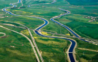
Sacramento River Flood Control Project | California is looking to expand the Sacramento River Flood Control Project, partly as a defense against severe storms in a changing climate. This study creates a model of the Project for exploring various scenarios. Researchers are analyzing how the system's bypass channels and weirs interact during big storms and how expansions of these structures might reduce flood damage at various locations in the Sacramento Valley and the Delta. |

|
Using 2-D Models for Flood Insurance Maps | This project aims to improve the understanding and application of two-dimensional (2-D) models in producing flood insurance maps for California and the nation. |

|
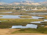
Yolo Bypass: Managing a floodplain for multiple uses | This study will present a decision-making framework for balancing ecosystem and economic goals on the Yolo Bypass, a promising site for habitat restoration in the San Francisco Bay-Delta system. The bypass's primary purpose is to provide flood control for Sacramento, but it's also used for farming, duck hunting and bird-watching. We're developing an optimization model to explore when, where and how floodwaters might most economically be applied to manage all the diverse activities. |
| Project | ||
|---|---|---|
|
|
Reconstructing Juvenile Salmon Growth, Condition, and Delta Habitat Use in the 2014-15 Drought and Beyond | This study uses otolith chemistry and microstructure to monitor how salmon use the Delta as rearing habitat and a migratory corridor, and the mechanisms cuing their outmigration from natal rivers. We will quantify the extent to which Delta-rearing contributes to salmon population resiliency under different conditions (including drought and flood conditions) and provide baseline data to assess population responses to future habitat restoration and changing climate. Physical tags are limited to larger fish that are more sea-ready than fry, and are thus ineffective to estimate the full rearing potential of Delta habitats, while abundance surveys provide only a snapshot of information. Otolith reconstructions allow us to estimate “who” is using the Delta (which populations and life history types), for how long, and their growth rates relative to other rearing habitats. This project will generate empirical data that will inform management actions aimed at maximizing salmon abundance, life history diversity, and resilience to future stressors. |

|
Comparing Futures for the Sacramento-San Joaquin Delta | The 2007 Envisioning Futures report (below) concluded that the Delta is no longer sustainable and that the need for a new Delta strategy is urgent. A follow-up report in 2008, Comparing Futures for the Sacramento–San Joaquin Delta, took a closer look at the range of viable options for the Delta. Among the central findings: A peripheral canal—conveying water around the Delta instead of through it—should be part of a long-term strategy for the Delta to serve both water supply and environmental objectives. The report was authored by a multidisciplinary team of experts, including University of California, Davis scientists Jay Lund, William Fleenor, William Bennett, Richard Howitt, Jeffrey Mount, and Peter Moyle and the Public Policy Institute’s (PPIC) Ellen Hanak. |

|
Delta Consumptive Water Use Comparative Study | This research project was convened by the Center for Watershed Sciences at the University of California Davis with financial support from the California State Water Resources Control Board Office of the Delta Watermaster and other agencies. Its objective is to develop a better understanding of consumptive water use in the Delta by coordinating modeling, measurement, and other information from a variety of independent research and estimation efforts. |

|
Envisioning Futures for the Sacramento-San Joaquin Delta (2007) | Beginning in December 2005, a group of faculty and researchers affiliated with the UC Davis Center for Watershed Sciences/John Muir Institute of the Environment and the nonprofit Public Policy Institute of California (PPIC) began meetings to discuss the future of the Delta. The intent was to complete a major independent report analysing options for managing the increasingly unstable Sacramento-San Joaquin Delta. The group included Ellen Hanak (Economist) with PPIC and from UC Davis: Jay Lund (Civil and Environmental Engineering), Jeff Mount (Geology), Peter Moyle (Wildlife and Conservation Biology), Richard Howitt (Agricultural and Resource Economics), and William Fleenor (Civil and Environmental Engineering). |

|
Historical Delta Elevation Model | We developed novel methods to interpolate between sparse historical soundings, infer depths of non-navigable channels from channel width, and convert historical tidal datums to modern fixed datums. The resulting 2-meter resolution digital elevation model covers Delta historical channels, tidal wetlands, adjacent non-tidal freshwater wetlands and upland transitional areas below 25 feet in elevation. |

|
Integrated Environmental Modeling | The National Science Foundation is sponsoring an Integrated Modeling Workshop to explore ways to improve the development and application of modeling for multipurpose management of changing estuarine systems. The two-day workshop will bring together experts from Europe, Asia and across the U.S. Potential solutions will be identified and discussed from multiple perspectives: government, academia, NGOs, consultants and stakeholders. |

|
Stockton Deep Water Ship Channel | The Central Valley Regional Water Quality Control Board has listed the San Joaquin River Deep Water Ship Channel (DWSC), located near Stockton, California, as "impaired" under the Clean Water Act. |

|
Water Quality and Hydrodynamics | Sea level rise, large-scale flooding, and new conveyance arrangements for water exports may increase future water salinity for local agricultural production in California’s Sacramento-San Joaquin Delta. Increasing salinity in crop root zones often decreases crop yields and crop revenues. Salinity effects are nonlinear and vary with crop choice and other factors including drainage and residence time of irrigation water. Here, we explore changes in agricultural production in the Delta under various combinations of water management, large-scale flooding and future sea level rise. |
| Project | ||
|---|---|---|

|
Striped Bass: Population Dynamics and Ecology of an Iconic Alien Species | The focus of the Striped Bass project is to update understanding on striped bass demographics in the San Francisco Estuary and compare data with populations on the Atlantic Coast and elsewhere. The study will rely on existing and new research, including radio-tagging and stable isotope analysis. |
|
Suisun Marsh Fish Study | For over 35 years, this project has monitored abiotic and biotic conditions in tidal wetlands, making it the longest established study in Suisun Marsh. The long-term data collected has enabled numerous studies and will continue to support research on the ecology and conservation of Suisun Marsh fishes, as well as the effects of Marsh restoration and management, and climate change. |

|
Blacklock Fish Study | The Blacklock Fish Study focused on gaining a better understanding of how managed wetlands compare with restored tidal wetlands. This project collected and compared data on the distribution and abundance of fishes between three key locations: subtidal sloughs, restored tidal wetlands, and managed wetlands. |

|
The Complete Marsh Project | The aim of the Complete Marsh Project is to understand the effects of hydrogeomorphology on estuarine food and juvenile fish distribution. |

|
Zooplankton ID Guide Project | This project involves the development of an online resource for the purpose of efficient identification of zooplankton samples for other UCD research endeavors such as the ARC Project, the Suisun Ponds Project, and the Complete Marsh Project. |
| Project | ||
|---|---|---|

|
A decision support system for water resources management: An Application to Monterrey, Mexico | This project integrates hydrologic and socioeconomic data into a water management decision support system using hydro-economic principles. Goals are to organize and exchange hydrologic and socioeconomic data; develop long-term hydrologic and socioeconomic scenarios; model a large, multi-objective metropolitan water system using hydro-economics; and identify and compare promising water management strategies. |

|
An Agent-Based Model of Farmer Decision Making in Jordan | The model employs a Multi-Agent-Simulation (MAS) framework and is designed to evaluate direct and indirect outcomes of climate change scenarios and policy interventions on farmer decision making, including annual land use, groundwater use for irrigation, and water sales to a water tanker market. |

|
Collaboration with Technische Universität München | UCD and the Technische Universität München (TUM) are conducting research to quantify changes in species distributions through the contraction or expansion of ranges. The collaborative effort began in 2011 with a two week summer school hosted by TUM. The main topic of the summer school was Life Sciences in the 21st Century with a Focus on Water. Later, beginning in April 2012, one of the participants of the summer school, Rebecca Quiñones, was awarded a one-year scholarship to pursue postdoctoral research at TUM. |

|
Dulcepamba Project | A coalition of Dulcepamba residents and their supporters contacted researchers from the Center for Watershed Sciences (CWS) at the University of California, Davis and asked them to complete a forensic analysis of the March 2015 flood and model the hydrology of the watershed. The UC Davis researchers developed (1) a hydrologic model of Dulcepamba basin; and (2) a hydraulic model to assess hydraulic and geomorphic processes associated with the March 2015 flood. |
|
Economic Assessment of Payments of Hydrologic Environmental Services in Mexico | PSAH programs give an economic incentive or cash payment to owners or holders of forest land for providing hydrological services. The lands must establish and implement a sustainable development plan and set of actions and be attractive to providers and beneficiaries of these services. In this report, a overview of payments for environmental services is presented with a case study in the region of Acayucan, Veracruz. |

|
El Ocote Reserve | Chiapas (Mexico) and California share many similar challenges regarding the conservation of rivers and streams and the organisms that dwell in them. Although fishes in both states are highly diverse, this biodiversity is under multiple threats including effects from cattle grazing, forest fires, dam operations, and climate change. Collaboration between the El Ocote Biosphere Reserve and the Klamath National Forest began in 1993 in order to provide research expertise and training between the two forests. Past efforts have documented fish species presence and distribution within the Reserve (2005-2008; Gonzalez-Diaz et al. 2008, Anzueto-Calvo et al. 2013), as well as identified threats to aquatic habitats (2010-2012). |

|
FABRI | The Middle East and North Africa have longstanding water supply and sanitation challenges. In 2011, US Agency for International Development (USAID) partnered with Development Alternatives Inc. to end the global freshwater crisis by implementing the Furthering the Blue Revolution Initiative (FABRI). This program helps create Middle East and North Africa Network of Water Centers of Excellence (MENA NWC). Designed and launched by USAID through FABRI, DAI has partnered with the UC Davis College of Agricultural and Environmental Sciences International Programs office to provide critical guidance on water resource and wastewater management in the formation of MENA NWC. The Center for Watershed Sciences is spearheading UC Davis participation in FABRI. |

|
Water Funds for the Ensenada Region | The Center for Watershed Sciences in Collaboration with researchers from the Universidad Autonoma de Baja California in Ensenada conducted a Pre-feasibility Assessment for a Water Fund in the Region. A Water Fund in the Ensenada Region may result an attractive water management tool for government agencies, water utilities, urban and agricultural water users and non-governmental or conservation organizations. |
| Project | ||
|---|---|---|

|
HOBBES | Water resource management in California is often extensive and complex and deserves a comprehensive data and modeling approach. The Hobbes Project is a new effort to provide a venue for modelers in California and elsewhere to create an open, organized and documented quantitative representation of the state's intertied water resources system. Geocoded elements in this database can be interactively converted into tiered networks able to be solved by multiple modeling platforms depending on user preferences, with the appropriate translators. Many Hobbes tools will be web-based with exporting capabilities to the most common analytical and modeling software. |

|
CALVIN | California’s complex water management system often defies comprehensive analysis. We summarize the results of a decade of quantification and analysis of this system from a hydro-economic perspective using the CALVIN Model. |
|
|
Historical Delta Elevation Model | We developed novel methods to interpolate between sparse historical soundings, infer depths of non-navigable channels from channel width, and convert historical tidal datums to modern fixed datums. The resulting 2-meter resolution digital elevation model covers Delta historical channels, tidal wetlands, adjacent non-tidal freshwater wetlands and upland transitional areas below 25 feet in elevation. |
|
|
Integrated Environmental Modeling | The National Science Foundation is sponsoring an Integrated Modeling Workshop to explore ways to improve the development and application of modeling for multipurpose management of changing estuarine systems. The two-day workshop will bring together experts from Europe, Asia and across the U.S. Potential solutions will be identified and discussed from multiple perspectives: government, academia, NGOs, consultants and stakeholders. |
|
|
An Agent-Based Model of Farmer Decision Making in Jordan | The model employs a Multi-Agent-Simulation (MAS) framework and is designed to evaluate direct and indirect outcomes of climate change scenarios and policy interventions on farmer decision making, including annual land use, groundwater use for irrigation, and water sales to a water tanker market. |
|
|
Economic Assessment of Payments of Hydrologic Environmental Services in Mexico | PSAH programs give an economic incentive or cash payment to owners or holders of forest land for providing hydrological services. The lands must establish and implement a sustainable development plan and set of actions and be attractive to providers and beneficiaries of these services. In this report, a overview of payments for environmental services is presented with a case study in the region of Acayucan, Veracruz. |
| California Fourth Climate Change Assessment | To more accurately estimate the threat posed by sea level rise and intense storms to coastal infrastructure, this research will provide assess coastal flood risk accounting for changing climate patterns, erosion rates, shifting beach forms, and vertical land movement. Methods will be developed to support site-specific, project level assessments of coastal vulnerabilities to sea level rise through integration of models of projected sea level rise and climate scenarios, coupled with local and regional-scale erosion rates and vertical land motion estimates. | |

|
Code Library and Tools | As part of numerous other projects, Center for Watershed Sciences staff and researchers have developed code to run analyses, organize and store data, interface with other systems, automate processing, and more. Some of this code is designed to be reusable as standalone products, or as code in other, larger projects. You can find this code below. |

|
HaD to Py | HaD to Py stands for HDF and DSS to Python, and it extracts results from the output file from a HEC-RAS simulation and creates plots which can quickly be viewed spatially against observed data for calibration or validation. The main advantage is that in 2D areas making these plots can be a little tedious. This tool makes accessing plots easier when computing different plans, changing the shape/name/cell size of a 2D area, and implementing other RAS changes between plots. The code is free and easy to use, and it is also easy to modify or adapt to your needs. |

|
PISCES - Fish Distribution Tracking, Modelling, and Analysis | PISCES is software and data describing the best-known ranges for California's native fish. The data is compiled from multiple sources and experts and is stored and exported as rangemaps and summary maps. As of December 2013, it includes data on all of the state's 131 native fish taxa as well as 48 non-native species. |

|
Satellite Remote Sensing and Consumptive Water Use in the Delta | This study for the state Delta Protection Commission compared the effectiveness of using new remotely sensed measurement technology to estimate farmers' "consumptive water use," or the amount of irrigation water crops transpire and evaporate from the nearby soil. |

|
Streamlapse: Time Lapse River Videos and Data | StreamLapse is a software system to build videos from time lapse river photos and data. It allows for rapidly viewing a season of rivers and cross-comparison between sites and years. |

|
SWAP Model | This website provides and overview and resources on the Statewide Agricultural Production Model (SWAP). |

|
Water Modeling in Agricultural Production | This technical workshop in collaboration with the California Water and Enviornmental Modeling Forum (CWEMF). This workshop presents various alternatives for modeling the economics of water use and water scarcity within an agricultural production setting, with a particular focus on California. |
| Project | ||
|---|---|---|
|
|
Striped Bass: Population Dynamics and Ecology of an Iconic Alien Species | The focus of the Striped Bass project is to update understanding on striped bass demographics in the San Francisco Estuary and compare data with populations on the Atlantic Coast and elsewhere. The study will rely on existing and new research, including radio-tagging and stable isotope analysis. |
|
|
Suisun Marsh Fish Study | For over 35 years, this project has monitored abiotic and biotic conditions in tidal wetlands, making it the longest established study in Suisun Marsh. The long-term data collected has enabled numerous studies and will continue to support research on the ecology and conservation of Suisun Marsh fishes, as well as the effects of Marsh restoration and management, and climate change. |
| Project | ||
|---|---|---|
|
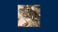
Habitat Models for the Foothill Yellow-legged Frog | This study compares commonly used methods of defining habitat suitability criteria and applying those to instream flow models for R. boylii in the Sierra Nevada of California. First, regional habitat suitability criteria (HSC) are developed using standard univariate and multivariate techniques, and the predictive performance and transferability of different HSC methods are evaluated. Second, three of the most commonly used instream flow assessment techniques are evaluated: (1) one-dimensional habitat modeling, (2) two-dimensional hydrodynamic modeling, and (3) expert habitat mapping (judgement-based mapping by species experts). A comparison table is provided to aid resource managers in selecting the most appropriate habitat assessment method for R. boylii given the specific conditions of a hydropower relicensing project. |

|
Hydropower Relicensing Project | The goal of the project is to develop the technical tools to allow licensees, stakeholder groups, regulators and others to evaluate or promote alternative strategies or efficiencies in relicensing. |

|
Long-term River Monitoring | The health and function of montane riparian and aquatic ecosystems should be monitored using quantitative, process-based, repeatable metrics in order for resource managers to consistently and affordably maintain, restore and conserve these dynamic environments. To increase our understanding and better assess the condition of riparian and aquatic ecosystems, we must link metrics of hydrologic alteration with quantitative assessments of physical habitat (geomorphology and water quality) and biotic communities. |

|
Management of the Spring Snowmelt Recession | In this project, we seek to improve our understanding of the impacts of varying spring flow regimes on stream ecology, through empirical field studies, and water management, through hydropower optimization modeling. |

|
Pulsed Flow Effects on Foothill Yellow-legged Frog | Over the last half century, the Foothill Yellow-legged Frog (R. boylii) has declined dramatically, especially in Southern California and the southern Sierra Nevada mountains. |
| Project | ||
|---|---|---|

|
Hat Creek Ecological and Geomorphic Assessment | Through consultation with CDFW, California Trout (CalTrout) initiated a “pilot” restoration project within the Carbon Reach of the Hat Creek WTA in October 2015. The focus of this pilot project was the introduction of large woody debris (LWD) structures to help stabilize fine sediment, increase spatial variability in flow velocities and depths, and also provide overhead cover to wild trout. Using high-resolution velocity and topographic data collected prior to and following the installation of LWD structures in Hat Creek, the UC Davis Center for Watershed Sciences evaluated hydraulic and geomorphic changes to the Carbon Reach associated with restoration activities. |

|
Shasta River | Interdisciplinary teams of Center scientists are investigating the causes for the decline of salmon and steelhead in Shasta River, historically one of the most productive tributaries in the lower Klamath Basin. A large spring complex (Big Springs Creek) provides the majority of its water, particularly during the summer. |
| Project | ||
|---|---|---|
|
|
Economic Assessment of Payments of Hydrologic Environmental Services in Mexico | PSAH programs give an economic incentive or cash payment to owners or holders of forest land for providing hydrological services. The lands must establish and implement a sustainable development plan and set of actions and be attractive to providers and beneficiaries of these services. In this report, a overview of payments for environmental services is presented with a case study in the region of Acayucan, Veracruz. |
|
|
SWAP Model | This website provides and overview and resources on the Statewide Agricultural Production Model (SWAP). |

|
Agricultural Production, Water Use and Employment | This program quantifies agricultural production, land use, water use, economic value and employment using optimization approaches such as the SWAP model (http://SWAP.ucdavis.edu) and statistical information. |

|
Crop Economics Map 1998-2010 | This website provides preliminary information on irrigated land areas, water use and crop value over various hydrologic boundaries. Information from the California Department of Water Resources (http://www.water.ca.gov/landwateruse/anlwuest.cfm) on land and water use, and economic information from the SWAP model (swap.ucdavis.edu) for 20 crop groups are employed. |
| Project | ||
|---|---|---|
|
|
Reconstructing Juvenile Salmon Growth, Condition, and Delta Habitat Use in the 2014-15 Drought and Beyond | This study uses otolith chemistry and microstructure to monitor how salmon use the Delta as rearing habitat and a migratory corridor, and the mechanisms cuing their outmigration from natal rivers. We will quantify the extent to which Delta-rearing contributes to salmon population resiliency under different conditions (including drought and flood conditions) and provide baseline data to assess population responses to future habitat restoration and changing climate. Physical tags are limited to larger fish that are more sea-ready than fry, and are thus ineffective to estimate the full rearing potential of Delta habitats, while abundance surveys provide only a snapshot of information. Otolith reconstructions allow us to estimate “who” is using the Delta (which populations and life history types), for how long, and their growth rates relative to other rearing habitats. This project will generate empirical data that will inform management actions aimed at maximizing salmon abundance, life history diversity, and resilience to future stressors. |
|
|
Perennial Pepperweed Control Project | Perennial pepperweed, Lepidium latifolium, is a highly invasive perennial herb that can thrive in a wide range of habitats including riparian areas, wetlands, marshes, and floodplains (Bossard et at. 2000; Young et al. 1995). |
|
|
Economic Assessment of Payments of Hydrologic Environmental Services in Mexico | PSAH programs give an economic incentive or cash payment to owners or holders of forest land for providing hydrological services. The lands must establish and implement a sustainable development plan and set of actions and be attractive to providers and beneficiaries of these services. In this report, a overview of payments for environmental services is presented with a case study in the region of Acayucan, Veracruz. |

|
Impacts of hydrograph shape on sediment transport | Building from a 2011 National Center for Earth Surface's (NCED) Visitor's Program Grant completed in collaboration with colleagues at University of Idaho's Center for Ecohydraulics Research, this project seeks to understand the impacts of hydrographs on sediment movement. |

|
Sacramento River Vegetation Map | This project will be used to post reports and other materials associated with DFG/Calfed Ecosystem Restoration Program Grant ERP062002. |